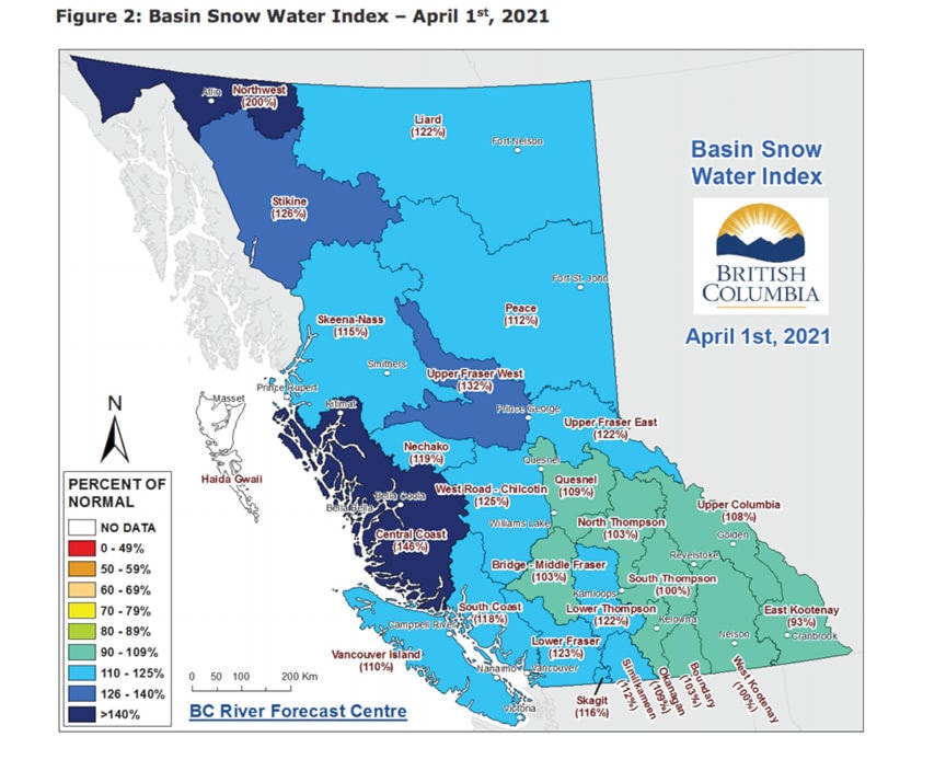
Snowpack assessments for early April reveals above normal levels for northwestern British Columbia and the Burns Lake region.
The Upper Fraser West basin, which includes Burns Lake, Fort St. James and Vanderhoof, has a snowpack level of 132 per cent of normal, according to the April 1 data from the BC River Forecast Centre.
The level was 127 per cent of normal for March.
The neighbouring basin of Nechako – in areas including Tahtsa Lake, Skins Lake and Mount Pondosy – is at 119 per cent of the normal snowpack level. It was at 117 per cent of normal in March.
The Skeena-Nass basin – northwest of Burns Lake and comprising Houston, Smithers and Terrace – is at 115 per cent, slightly up from 114 per cent in March.
The highest recorded level is in the Northwest basin – bordering Alaska and the Yukon – at 200 per cent of normal while the lowest recorded level is in East Kootenay at 93 per cent of normal.
Historically, a decrease in snow levels can be seen between April and May and normally, the levels stay same. However, in some years such as last year in 2020, the snow levels went down from 135 per cent of normal in March to 129 per cent of normal in April in the Upper Fraser West basin; in 2019 it went down from 106 per cent of normal for March to 94 per cent of normal in April; in 2012 it went from 144 per cent above normal to 152 and in 2013 when it rose from 103 to 119.
The higher levels across the province imply increased flood risk during the spring snow and ice melt, or freshet season.
During the spring snowmelt period, short and mid-range weather forecasts are more critical compared to seasonal weather predictions. According to the survey, since mid-March, temperatures have remained seasonable to slightly below normal throughout the province, resulting in a slight delay in snow melt. However, an upcoming warm spell beginning the week of Apr. 12 will kick start snow melt at low and mid elevations throughout the province. The warm weather may create challenges for smaller creeks and lower elevation areas; however, the upcoming warm weather may be considered a positive for larger, higher elevation watersheds.
While snowpack is one risk factor for flooding, snowpack alone wouldn’t be sufficient to predict whether flooding will occur or not. Spring weather is also critical, where the timing and severity of temperature and rainfall patterns are important drivers of flooding irrespective of snowpack.
Priyanka Ketkar
Multimedia journalist
@PriyankaKetkar
priyanka.ketkar@ldnews.net
Like us on Facebook and follows us on Twitter.